Sunday, March 29, 2009

Colombia River Gorge

hood riverFor anyone that is a windsurfer the Colombia River Gorge is a required pilgrimage. The river separates Washington and Oregon emptying into the Pacific Ocean just west of Portland Oregon. To wind surfers its just called “The Gorge”. It is indeed a gorge. The Colombia river running out of the high plains to the east has eroded a deep gorge between mountain peaks as it wanders its way to the ocean.


Swellcity Weather conditions on the coast in the months of June, July, and August are daily high pressure systems, and the weather inland on the high plains are hot dry low pressure systems.  This creates strong winds traveling east up the river. Combine that with a 5 mile and hour current flowing west as the water flows downhill and you get some incredible waves and windsurfing condition.

There are a few locations where the river narrows to a few hundred yard across between high mountain cliffs on each side that act like a funnel creating extremely high winds and waves. That is of course where thousands of people go to sail.

I have flown out to the Gorge on a surfing trip the previous summer  but this summer we were planning a road trip. The trip would of course include plenty of windsurfing, but also biking, camping, and hiking in the Hood River area as well as the Pacific Ocean. The trip would last two weeks and we were taking our jeep and pulling our windsurfing trailer with our bikes and camping gear.

Here’s Margaret at a rest stop on Interstate 90 somewhere in the Great Plains heading west towards the Pacific Ocean. Its a 3 day drive and almost 2000 miles from where we were living.

Our plan was to camp at different places on the way out to the Gorge and a few days while we were there, but some of time while in Hood River we planned on staying at a hotel that had a hot tub to sooth aching muscles after windsurfing on the river.

Here we are parked at a campground near Missoula Montana about to grill supper after a days driving.

The scenery in the Rocky Mountains is fantastic requiring a stop along the road for pictures and a break.

Somewhere in Idaho on the Lewis and Clark trail we stopped for lunch along a beautiful little river flowing next to the road where there was a gravel pull out. We packed our lunch and went down by the river and discovered one of those places that you remember for the rest of your life. There was no one else anywhere around, but the trusty timer on our camera at the time recorded a few images for us.


We arrived at the east end of  the Columbia River later in the day and decided to camp at an Army Corp of Engineers campground along the river.  We set up the tent in a spot right next to the river had dinner and a beer and went to sleep in out tent.

Later in the evening we were awaken by a horrible noise and the tent shaking violently.  At first we thought someone was out there shaking the tent, but quickly it became obvious that the wind was blowing very hard causing all the noise and shaking.  We  got dressed and went out to see what had happened. Checking out the campground all the tents in the park were blown down. It appeared that there had been a brief violent downdraft of wind that had knocked all the tents over except ours.

The next day we moved on down the river to a hotel near Hood River where we stayed for several days using it as a base camp to surf, bike and hike out of.  They has a nice pool, hot tub and a comfortable room to return to after a full day of play.

Daily when the wind was blowing we hit the river and sailed. There was always plenty of people on the beach to watch and great sailing.


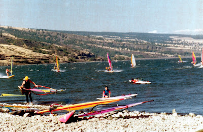
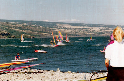
One of the reasons the sailing at the Gorge is so great certainly is the steady wind, but because the current flows against the wind you never lose ground on a high speed run across the river. This is unlike normal sailing on a lake where you are forced to tack back into the wind at slower speeds to not lose ground.

On one of the days when the wind was not blowing so hard we took our bikes out onto one of the many biking trails in the mountains south of Hood River near Mount Hood.

The bike trail turned out to be more pushing and carrying than riding, but it made for an exciting time and a good day.

The bike trail ultimately took us to the top of a minor peak with a great view of Mount Hood in the background,


Nearing the end of out time in Hood river we took a day and traveled to the Pacific  coast along Highway 1. Our intent was to sail on the ocean for a day, but the wind wasn’t cooperating. While I never got to sail the Pacific the views and coast were outstanding. We settled for lunch and a picnic along the beach before working our way back to Hood river.

The Gorge trip was one of the few long cross country driving trips we have ever taken due to our time spent at the lake. As life leads us onward I think that we will see that change.

Saturday, March 28, 2009

Bungee Jumping


I learned early on when I meet Scott, that  he was a bit of a dare devil so it was  of  no surprise to me when he told me he had signed up to bungee jump for charity one summer.  He said it was for  a good cause.. I knew for sure that  the charity was not what he had in mind.
Since the so called charity event was going to be held at Lake Washington on a Saturday and we often would go boating there it was going to be a party weekend. I was friends with some of the other dare devils wives', and we all had boats. It was going to be a day of fun with friend at the lake even thought I did not like the bungee jumping. We set out with our boat,  beer, and food for an afternoon of sun, fun, and adventure at the lake.

While the audience could  have a beer as soon as we got our boats in place for the show, the bungee jumpers had  to put on a  show first before they could have  their beers.  So they had to wait!
Here is Scott getting ready to go up for the big jump
Finally at the top are you really going to jump or come back down.
I Guess he jumpedimg900 
I  would like to add that I did not take these picture or did  I even see Scott jumping out I closed my eyes. I could not look I was so afraid. 
A  Happy Bungee Jumper heading for the boat for a beer, and a day of celebrating with friends, and fun in the sun at the lake.
img904
Congratulation Scott, sorry we were so excited, we drank all the beer.

Saturday, March 21, 2009

Carlton Peak Lake Superior

tofteOften we would take a trip to the North Shore. Its a beautiful place and the hiking and scenery is great for Minnesota.
We have stayed several time in Tofte a small village just south of Grand Marais. This trip we stayed at the Bluefin Bay Resort which is just down the road from the trail-head to Carlton Peak.
Carlton Peak is part of the Temperance River State Park as well as the Superior National Forest, along beautiful North Shore of Lake Superior. It is a high point just along the lake and has spectacular views of Lake Superior
The trail-head is just off country road 2 and the trail is a segment of the Superior Nation Hiking trail that runs along the North Shore atop the Saw Tooth Mountains (What passes for Minnesota Mountains).
We arrived mid morning and parked the jeep at the trail-head, loaded our day packs, and cameras and were off on the trail.

The trail is fairly easy, and well used as it winds its way to the top of Carlton Peak. Our beautiful tour guide for this trail hike points out the unique Birch tree groves that we are making our way through.


Farther along the trail we skirt huge granite boulders covered with moss.


Since the peak is only 500 feet or so above the surrounding area its an easy hike and we arrive at the top in a couple of hours. The top has surveyors mark.

You can still see the remains of an old fire tower that was taken down years ago.

Margaret takes time to do some Yoga in a beautiful serene setting.

In the distance you can see an old lighthouse on the lakeshore.

While we were there a couple of other hikers arrived at the top and offered to take our picture if we would take theirs. So we exchanges cameras and photos.

To the west out over Superiors National Forest the trees are starting to turn red in their annual fall display of colors. Its not the peak yet, but its still a great view.


As the sun starts to set and cast long shadows on the beautifully colored forest bringing on the night……

The moon rises over Carlton Peak!

Not really…… I was just waxing poetically and that was really Margaret still doing her Yoga on Carlton Peak!
Enjoy Life

Monday, March 16, 2009

Windsurfing Mille Lacs Lake

Wind surfing has been a large part of my life for many years you can see some of the photos from trips windsurfing in the North Sea. When I was in Minnesota I often surfed on the lakes there in the spring and fall when the winds are blowing hard.

Every Year for many years running I was a participant in the Mille Lacs Lake Crossing. This is a windsurf race across Lake Mille Lacs. If your not familiar with the Lake it is one of the largest lakes in Minnesota. (and in Minnesota that’s saying something). It is 25 miles across at its widest point. When you are standing on the beach at one side you cannot see the other shoreline. It disappears because of the curve of the earth.

If you happen to be out on the lake when the winds get to blowing 25 miles and hour plus the waves can get up too 10 or 12 feet tall. Small boats don’t stand a chance on the lake when the wind is blowing that hard. However windsurfers with there ability to lay in the water and restart without swamping like boats can have a great time out there in the big waves.

The Mille Lacs crossing would often draw a 100 or so surfers to the town of Garrison on the shores of Mille Lacs for the weekend late in September when its held. People would camp and stay in RV’s or hotels and make a weekend festival of it. The crossing then would be held on either Saturday or Sunday depending on what day was the best wind day. There was banquets and party’s, breakfast was served, and a great time was usually had around the campfire at night or in the Casinos nearby.

People would pull all sorts of different trailers filled with their windsurfing equipment and park it by the beaches where they were sailing.

Here is my trailer and rigs for one of the races.

Some times the race would be over in 45 minutes. If you have a 30 mile and hour wind blowing you can cross a 25 mile long lake in 45 minutes on a windsurfer. Other years with not so much wind it could take 4 or 5 hours to cross. It is always a puzzle as to what rig you should run on the lake because the wind can change with a moment notice and if you happen to have too big or too small of a sail on out in the lake for the wind you are in for trouble.

Some years there would be a large 50 foot launch boat that followed with observers in. This allowed the spouses to come along for the ride so to speak.

Other years the wind blew so hard the boats were forced off the lake. I remember one year getting lost on the lake because you could not see the shore in any direction. The waves were so high and the gray mist from the wind and water made it impossible to see. Unable to see the lead boat I got off course and missed the finish line by 5 miles.

The fastest crossing were always the most fun, but no matter what the weather for the weekend turned into there was always fun. Wind surfing was certainly an adventure.

Sunday, March 15, 2009

Eagle Mountain, MN

Eagle Mt MnIn keeping with the theme of many of our adventures which is “standing on the highest rock around” its no surprise that at some point we would find ourselves standing on the highest point in Minnesota.

The high point in Minnesota? There is no Mountains in Minnesota is there? Well not really, but if you go to the North Shore along Lake Superior you can find what passes for mountains in Minnesota. The highest point in Minnesota is Eagle Mountain. Its located in the arrowhead region about 2o miles from the North Shore down some seriously bad roads inside what is called the Boundary Water Canoe Area . The trail guide will tell you that the trail to the top of Eagle Mountain is a bit of a nasty rugged trail and about 3.5 miles to the top 7 miles round trip from the trailhead. At 2301 feet above sea level with only a 500 foot elevation gain from the trail head its not much of mountain climb. However the trail is rocky and slippery with a number of swamps to cross to get there.

So one cool autumn morning in late September found us at the trail head to Eagle mountain. We had just driven down 20 miles of the muddiest nastiest road you have ever seen and were standing ankle deep in mud outside our jeep in the pouring 35 degree rain thinking to ourselves “ Maybe we should try this hike another day?”

Well we were here, we had rain coats and we also had a change of cloths along just in case so why not! Lets give it a go its only 3.5 miles. So off we went searching for the summit of Eagle Mountain in the rain.

After a mile or so we came upon a swamp that had to be crossed. Fortunately some enterprising ranger had made an old wooden bridge so we wouldn’t have to get our feet any wetter than they already were. (They couldn’t really get any wetter)

Just past the bridge we crossed the border into the BWCA

About halfway to the summit is Whale Lake where there is a couple of camp sites on the lake shore. Not surprisingly there was no one camped there in the 35 degree rain.

Just past the lake, the trail splits and there is a sign post shrouded in mist today where you can start the climb to Eagle Mountain or skirt it and head to another lake on the other side of the mountain.

About an hour and a half into the hike we find the top of Eagle Mountain. Its marked with a plaque telling about the original surveyors that discovered the Minnesota high point. Some previous hiker has left a small flag.

Here embedded in the top of the rock with the plaque is the surveyors medallion that marks the highest point in Minnesota. Hey we made it “ Standing on the highest rock around”

While the view is not quite as spectacular as some of the vistas from the Colorado peaks it still is beautiful even in the rain and mist.

Back down to the trail head now where lunch and a clean dry set of cloths waits at our jeep

Below you seen some of the local wildlife hiding. Its a rare drowned Irish rat.

Finally we arrive back at the trailhead. I have been looking forward a change of dry cloths for hours now.

Here we see the rare “Drowned Irish rat” again tell us how frozen here poor fingers are.

Now here is where the story get interesting! See in the photo below the nice nylon running pants that the Irish rat is wearing during the hike to the summit. She even mentioned during the hike that they were keeping her nice and dry.

You see those were “MY SPARE DRY CLOTHING” she had put them on over her regular pants when she was getting ready for the hike without me noticing. My dry pants that I had been looking forward to for hours had accompanied us on the hike, but they were no longer dry! I was going to stay wet for another hour or so on the muddy ride back to civilization.